Introduction
Clean water, safe roads, accessible broadband, and electricity – these are not luxuries, but fundamental necessities that underpin modern society. Yet, despite their importance, many of America’s infrastructure networks are in disrepair, failing to provide the level of service that citizens expect.
According to a recent report card from the American Society of Civil Engineers (ASCE), the country’s aging infrastructure is ranked a dismal C-. The problem is not just one of funding; it also requires better data and mapping capabilities to ensure that infrastructure providers can identify and prioritize repairs, upgrades, and maintenance.
Enter Mach9: Using AI to Improve Infrastructure Mapping
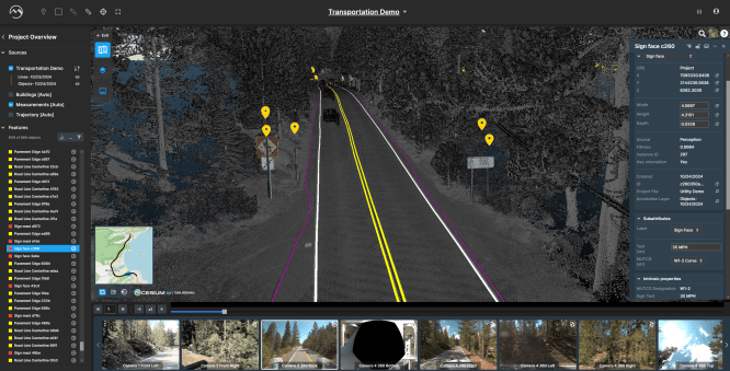
Mach9, a startup founded in 2021, has developed a solution to this problem. The company’s flagship product, Digital Surveyor, uses artificial intelligence (AI) to convert mobile lidar scans into 2D and 3D engineering models at a fraction of the cost and time than traditional processes.
Digital Surveyor can automatically identify over 20 features, including utility poles, traffic signals, and road signs. This is a significant improvement over the current manual process, which requires human operators to manually identify these features, often taking days or even weeks per map mile.
The Problem of Manual Identification
Currently, infrastructure providers rely on manual identification methods to gather data about their assets. However, this approach has several limitations:
- Time-consuming: Manual identification can take up a significant amount of time and resources.
- Inaccurate: Human errors can occur during the identification process, leading to inaccurate data.
- Costly: The manual process is often expensive due to labor costs and equipment maintenance.
How Digital Surveyor Works
Digital Surveyor uses AI algorithms to analyze lidar scan data and automatically identify features such as utility poles, traffic signals, and road signs. This enables infrastructure providers to:
- Streamline: Identify features quickly and accurately.
- Prioritize: Focus on high-priority tasks and allocate resources more efficiently.
Mach9’s Journey
Mach9’s co-founder and CEO, Alexander Baikovitz, has a background in robotics and surveying. He realized that many infrastructure problems are actually mapping and surveying issues. The company began developing Digital Surveyor to address these challenges.
Future Plans for Digital Surveyor
Baikovitz aims to expand the capabilities of Digital Surveyor, enabling it to identify over 100 features in the future. This would further reduce manual identification time and increase accuracy.
Conclusion
The state of America’s infrastructure is a pressing concern that requires attention from policymakers, industry leaders, and innovators alike. By leveraging AI technologies like Mach9’s Digital Surveyor, we can improve data collection and mapping capabilities, ultimately leading to more efficient and effective infrastructure management.